📊 Technical Details
Trail is well-marked throughout but involves significant rocky and uneven terrain, steep sections, and mandatory unbridged river crossings (minimum 3, more in high water). River crossings require wading knee-to-thigh deep in glacial meltwater — do not attempt alone and always check with hut wardens on conditions. Snow covers parts of the trail into July, requiring microspikes or crampons. Not technically difficult but demands genuine mountain experience and appropriate gear.
Well-marked with cairns and posts throughout. In whiteout conditions or heavy snow the trail can be difficult to follow; GPS and map essential. River crossings require route-finding judgement — the marked crossing point may not be obvious in high water.
Mix of compacted highland paths, loose volcanic scree, lava fields, black sand desert, and wet boggy sections. The river crossings guarantee wet feet. The Hrafntinnusker plateau section can be snowbound and slippery into early July. Footwear that can handle both wet crossings and rocky terrain is essential.
| T1 | Hiking: clear path, no exposure |
| T2 | Mountain Hiking: some uneven terrain |
| T3 | Difficult Mountain Hiking: exposed sections possible |
| T4 | Alpine Hiking: requires sure-footedness |
| T5 | Difficult Alpine Hiking: climbing experience needed |
| T6 | Very Difficult Alpine Hiking: advanced mountaineering |
| Info | Visit About > rating notes or SAC hiking difficulty ratings |
| A dream | Paved/hardpack (but you might reconsider after a 10-hour day) |
| Too easy | Firm dirt/gravel |
| Mind your step | Loose/uneven |
| A bit of a slog | Ongoing sapping surfaces |
| Make it stop! | A total energy sucker |
📅 Best Season
The trail is only open from approximately late June to mid-September when huts are staffed. Outside this window huts are unstaffed and locked, camping is prohibited, and the trail is dangerous for all but experienced winter mountaineers. Early July still has significant snow. Late August/early September offers lighter crowds and dramatic autumn colours but huts close progressively from mid-September. Always check safetravel.is and trail conditions before setting out.
💭 Logistics & Budget
Iceland is one of the most expensive countries in the world and the Laugavegur reflects this. Dirtbag assumes camping (~€21/night) and all food brought from Reykjavík supermarkets. Average assumes a mix of camping and huts (~€105/night) with self-catered meals. Flashpacker assumes huts every night plus meals purchased at huts. All budgets exclude transport to/from Reykjavík (~€80 return bus per person) and flights. Bring cash — most huts accept cards but connectivity is unreliable.
No hiking permit required. However, booking hut or campsite accommodation in advance through FÍ (fi.is) is mandatory and constitutes proof of right to hike the trail. Hikers without bookings may be turned away. Hiker registration with safetravel.is is strongly recommended.
No private vehicle access to Landmannalaugar without a 4WD capable of fording rivers — parking is extremely limited and reservation required in peak season. The standard approach is by Reykjavík Excursions highland bus from Reykjavík (BSÍ bus terminal), ~4 hours. Buses run late June to mid-September only. Þórsmörk is similarly accessed by highland bus only. Plan return bus in advance as seats sell out.
Accommodation is exclusively FÍ (Icelandic Touring Association) mountain huts and their adjacent designated campsites. There is no other option on-trail. Huts cost ~ISK 15,800 (~€105) per person per night (2025 prices); designated camping ~ISK 3,200 (~€21) per person per night — booking in advance is now mandatory for both. Bookings open in autumn for the following summer and huts fill within hours of release. Wild camping is strictly prohibited; you may only camp in designated areas adjacent to huts. No meals are provided — hikers bring all food from Reykjavík or cook in hut kitchens. The private Volcano Huts in Þórsmörk offer a more comfortable option with a restaurant.
🎶 Vibe
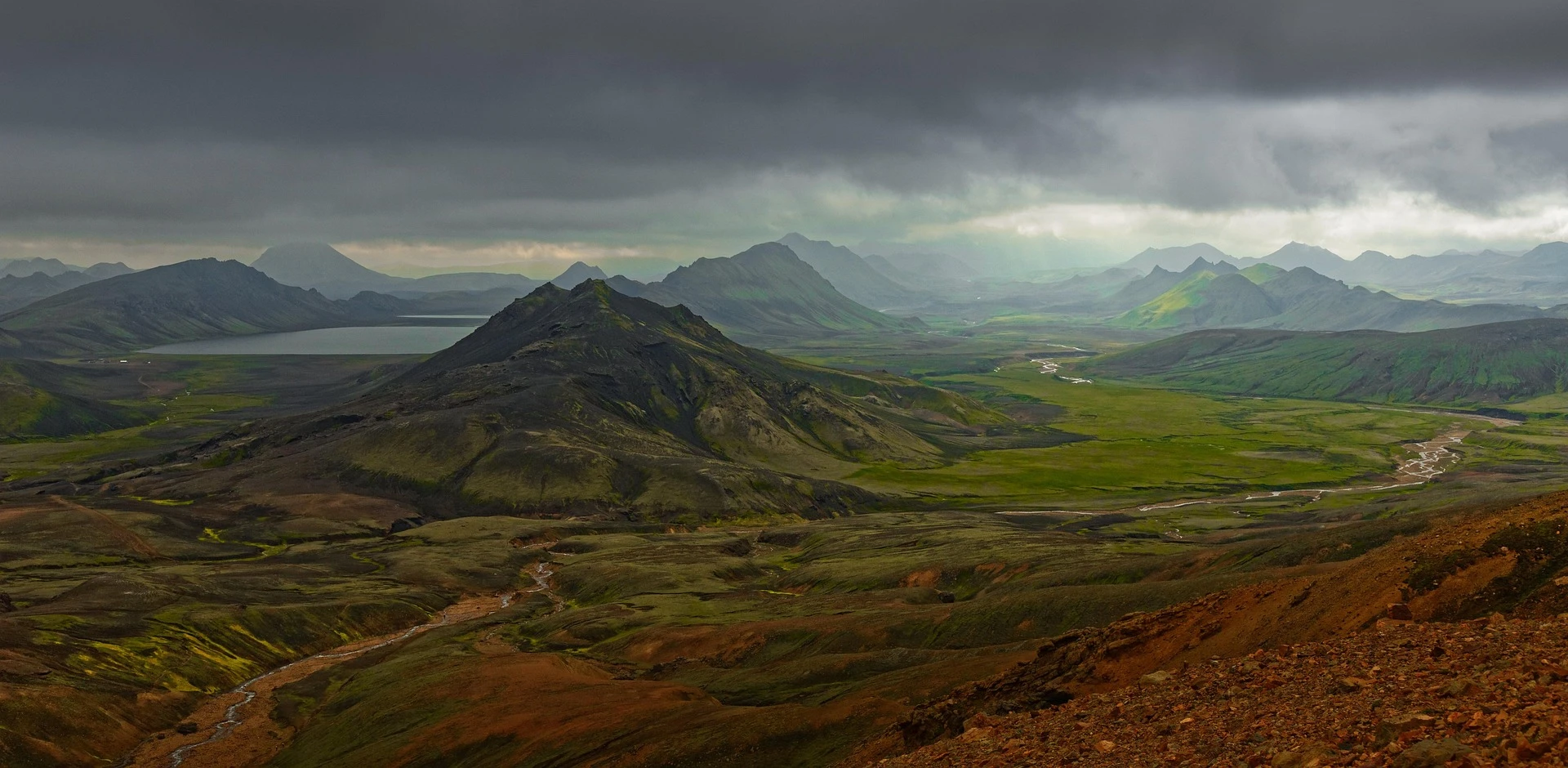
The Laugavegur is one of the most visually extraordinary hikes on earth — multicoloured rhyolite mountains, obsidian fields, steaming geothermal vents, glaciers, and black sand desert, all within 55km. The hut system creates a naturally social atmosphere; the small community of hikers sharing kitchens and meals each evening generates real camaraderie. But the trail demands respect. Weather changes violently and without warning. The river crossings have a sobering effect on even experienced hikers. There is a strong sense that you are genuinely in the wilderness, despite the marked trail and staffed huts. A profoundly memorable experience for those prepared for it.
🛟 Safety & Inclusion
The Laugavegur passes through genuinely remote volcanic highland with rapidly changing weather — fog, whiteout, high winds and snow are possible in any month. The river crossings are the primary serious hazard; never cross alone, always check water levels with hut wardens, and turn back if in doubt. Iceland’s highland interior has no road access or emergency infrastructure. Register your hike at safetravel.is and carry an emergency beacon (PLB or satellite messenger) strongly recommended.
📍 Trails in the Same Region
Suggest a correction
Help keep Laugavegur Trail accurate. Only the values you change are submitted, and every suggestion is reviewed before going live.